A couple of weeks ago, I was chilling at a favorite watering hole when I met a nice young lady, a visitor who was up here to hike. We started discussing the best trails. And she complained, “You know, they’re all too short. Like, a couple of miles. Where are the long ones?”
I realized she had a good point. Leelanau County isn’t limitless. We’re a peninsula, after all. An impressive portion of the land has been protected by the Sleeping Bear Dunes National Lakeshore or the Leelanau Conservancy, so there’s plenty of nature — nature galore, nature everywhere you look. But medium-to-long hiking trails are few and far between.
Many of the most beloved trails, including Pyramid Point and Empire Bluff, are out-and-back hikes to an overlook. You walk up the hill, you behold a spectacular vista, you walk back down. Which is great! And I’d guess that most people aren’t looking for a strenuous hike when they come to visit this area.
But some people are. Some people want that vigorous exercise, that stretching of legs, that feeling of accomplishment and pride when you arrive back at the parking lot, exhausted, and think to yourself “I did it!”
So for the moderate/advanced hikers visiting this area, here are two spots I’d recommend. Granted, they’re not as long and challenging as certain hikes in Michigan’s Upper Peninsula, such as the Chapel Loop Trail at Pictured Rocks. But they’ll suffice, especially if you do them the “right way” (the long way). You’ll experience that rewarding feeling, which every hiker knows, of being glad to be back at your car.
1. Leelanau State Park
 As you drive north beyond the lovely town of Northport, toward the lighthouse at Michigan’s pinky, you’ll see a brown sign for state park trails on your right. It’s easy to miss, so keep an eye out for it.
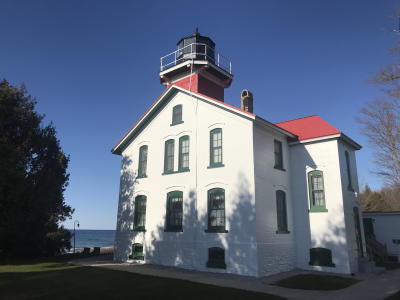
(The Grand Traverse Lighthouse, by the way, is well worth a visit. It was recently refurbished and looks brand new, glimmering with bright white paint and a red roof.)
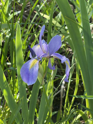 Turn left at that sign, onto Densmore Road. You’ll be driving through a swampy area which is a natural marvel in and of itself. Right now, the wild native irises are blooming along the side of that road. Drive carefully, because a turtle may be crossing. I’ve heard tales of cougar sightings on that road…but of course, there’s never any photographic proof, so who knows what to believe. In the fall, the tamarack trees lining Densmore glow with an enchanting golden aura.
 At the trailhead, you’ve got some options. Taking the Blue Trail to the beach of Cathead Bay is the most highly trafficked option. But if you’re wanting a long hike, and more solitude here’s what you do.
 Do the longest loop you can, counter-clockwise (i.e. “backward”), on the Orange Trail. You’ll start off on a handicap-accessible portion of the trail — a rarity around here. And then, ironically, you come to the trickiest portion of the trail — a muddy, swampy gauntlet. Good samaritans have set down logs which you can teeter on, to cross this section, but really the DNR or someone should build a boardwalk there. Once you’re past that part, it’s smooth sailing.
This is important: be sure to take the Pothole Ridge crossover trail. It takes you up on top of a high mossy ridgeline, through multiple lovely boardwalks, and you get a sense of the topography of the park. What you’re glimpsing below you, I believe, are kettle holes left by glaciers. (See my previous post about the Kettles Trail). This is arguably the most beautiful section of the park, and most people skip it.
The Pothole Ridge section drops you back onto the main Orange Trail loop, and you soon reach a bridge over a swamp. During early spring, the spring peepers go bonkers there. I’ve never heard them louder. Almost deafening. And in late summer, the poisonous, invasive, multicolored, and very beautiful bittersweet nightshade berries grow along that bridge. Even evil, it must be said, can be beautiful at times.
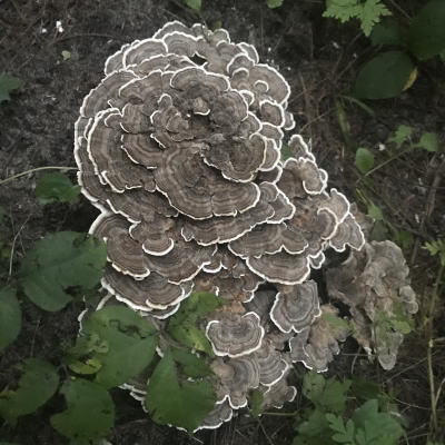
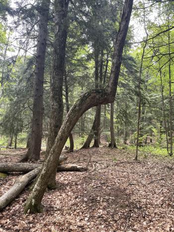 Then you’re into the long-slog backside of the trail. Many great hiking trails have a long and kinda boring part, and this is that part. Except, in late summer and fall, you’ll be seeing a ton of mushrooms of all different shapes, sizes, and colors — the vast majority of which you will not want to eat, but which are fun to look at. And also…there are some Indian marker trees to be seen on this stretch of the trail if you know what you’re looking for. Indian marker trees are trees that were shaped/trained by the native inhabitants of our peninsula to serve as directional signposts. When you see a weird zig-zag in the middle of a tree, it could be a marker tree. In my idiotic ignorance, I was skeptical of the purported existence of marker trees in Northern Michigan until I joined some friends, including a Native friend, on a trip to Beaver Island. There were tons of marker trees there, and they were unmistakable. I’m hesitant to even mention their presence at the Leelanau State Park because to me they’re somewhat sacred. But I think it’s important for everyone to understand that there was a civilization living on this land before people of European descent arrived. These trees bear witness to an ancient past.
So, forget what I said…that section of the trail is most definitely not boring!
 Finally, you’ll come to the Blue Trail, with opportunities for two overlooks. The first path to an overlook leads you to a wonderful platform with an elevated view of Cathead Bay. This is a great chance to sit, and maybe a picnic, and feel like you’re in another world. I’ll never forget the first time I was there. Looking out at the dunes and beach, and turquoise waters, with the Fox Islands in the distance, gave me an uncanny sensation that I was in another country. Like Greece or Spain or something. You can never experience something for the first time twice. I will always remember my first time on that platform.
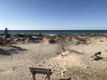
Then you double back and then continue counter-clockwise to trail marking number 3, which climaxes with an entrance (exit?) through a portal of trees into the bright sunlight of the dunes. Suddenly the entire soundscape and landscape transform, and you’ve gone from the dark mushroomy forest into blinding blue skies and the din of rolling surf. That vista of the beach, from the dunes, takes your breath away.
I often turn back here and finish the trail. But if you descend the dunes and continue to the beach…you’ll be happy you did. It is splendid. Swimming isn’t always the best here. Cathead Bay, for whatever reason, frequently traps debris, twigs, leaves, litter, even big pieces of wood…all sorts of things. Sometimes there’s so much stuff in the water that swimming could be dangerous. And yet, if you're there on a perfect day, in the perfect conditions when the bay has cleared itself out and the waters are pristine…[chef’s kiss]. If you’re lucky enough to be there on a rare day like that, buy a lottery ticket.
Re-entering the forest, you’re struck again by the change of soundscape, light, and energy. It’s like going down a rabbit hole into a cave. I love that shift of universes.
You’re not too far from the trailhead, at this point. But first, you’ll be passing through what I’ve heard described as a “dell”: a distinctly flatter and less densely wooded area. It feels totally different from the rest of the trail. My Native friend thinks, in her gut, that there may once have been a Native village there. I’ve learned to trust her when she gets a gut feeling about something.
Back at the trailhead, you’ll feel physically and spiritually satisfied. And if you’re me, you’ll be ready for a cold, cold martini (with pickled Brussels sprouts!) at Fischer’s Happy Hour Tavern on the drive back south. The best martini in the peninsula.
2. Alligator Hill
I do this hike every week, and I’ve blogged about it before in a different season and context. I’m kind of obsessed with it, to be honest. It’s epic every time, and I feel like I’ve mastered it. There’s a “right way” to do it, in my opinion, a way that maximizes the mileage and the ups and downs, and leaves you feeling like you’ve conquered this majestic hill and seen every facet of it.
Doing it this way gets you to about 7.7 miles.
Drive south from Glen Arbor on M-22, toward Glen Haven Historic Village. Take a left onto Stocking Rd. Then drive slowly….because if you blink, you’ll miss the national park sign for the trailhead on your left. Even after having done this hike a million times, I still drive past the trailhead sometimes and have to turn around. If you glimpse the famed D. H. Day Farm on your right, you’ve gone too far.
 Start off on the Easy Trail, bearing left toward the Lake Michigan Overlook.
(By the way, the funny thing about this hike is that the trails are misnamed: the “easy” trail isn’t particularly easy; the “intermediate” trail is the hardest, and the “advanced” trail is the easiest! My theory is that the stated challenge levels of these trails refer to the challenges for cross-country skiers, not hikers. And in that case…yes, I can see how the “advanced” trail would be the most gnarly. I’ve noticed this on the Bay View Trail as well, where “advanced” doesn’t seem to mean advanced unless you’re imagining skiing it. In any case, don’t trust those signs.)
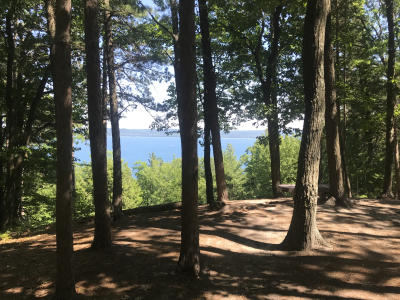
The Easy Trail brings you up to one of the most jaw-dropping overlooks in the region: a sweeping panorama of Sleeping Bear Bay, the Manitou Islands, and Sleeping Bear Point. It’s a nice reward for that arduous initial ascent. If you’re fortunate enough to be there on a crystal clear day — as I was today — you might see one or both of the Fox Islands, too.
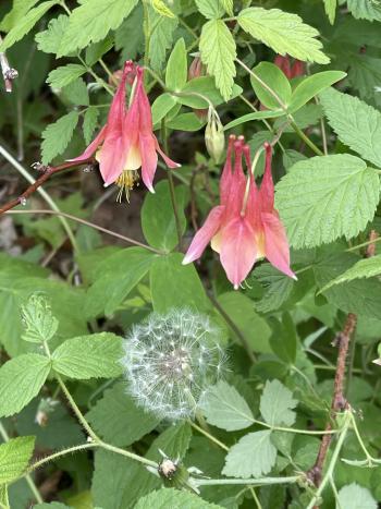
 Then proceed to the Big Glen Overlook. You’re walking on the ridgeline, on top of the world, flanked by columbines or daisies or whichever flowers the particular season is featuring. You arrive at a sacred (to me) grove of red pines, and a bench looking out at Glen Lake.
 Then you turn around and double back. And THEN you take your next right onto the intermediate trail. There’s no sign for it. So just go right when you can. You’re going all the way down the hill. The brush is overgrown in this downhill section of the hike, so wear your bug spray and check yourself for ticks after you’ve reached the bottom of the hill. I’m very concerned about ticks, and I hate brushing up against anything….but you’ll have to, in this stretch. It’s worth the risk. And I’m here to tell you that I’ve never been bitten by a tick in my life, despite my countless hikes. [KNOCK ON WOOD.] So don’t let paranoia stand in the way of a great hike.
 At the bottom of the hill, you feel a sense of *gulp*, because you know you’re going to have to climb back up to the top of the hill, where you were before. The good news is that there are three distinct ascents leading you back up, each of which levels off for a stretch, allowing you to catch your breath. The third ascent is the hardest part of the hike. It’s steep and grueling, and at this point, you’re starting to think about the trailhead and your car. But once you reach the top…you feel victorious.
 THEN you take a left — there is a sign — onto the Advanced Trail. Which is really the victory lap trail! Well, sort of. You have a few miles left to go. After a stretch on the ridgeline, you plummet down through an old oak forest and then continue on level ground, with tall trees shading the path. These are trees that *weren’t* destroyed by the infamous straight-line wind storm of 2015. You’re feeling good at this point. You’re almost there.
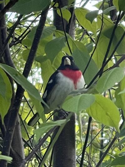 Of course, like in any good plotline of a movie, there’s one last challenge, one last hurdle, one last appearance of the monster before the fat lady sings. You need to ascend part of Alligator Hill — again! But this ascent always seems easier than the others, because it’s the last. It’s my favorite part of the entire hike, because of how rewarding it feels. You’re climbing up through that dark forest and emerging, as from a womb, into the joyous sunlight — into a section of Alligator Hill that *was* devastated by the 2015 storm. In place of demolished trees, a gazillion blackberry bushes have sprouted up, taking advantage of the now-naked sun. (Nature finds a way. When one door closes, another opens.) Birds find refuge among those bushes and flitter about. Later in the summer, when the berries are ripe, they’ll be the most delicious ones you’ve ever tasted. They’re your prize after a long hike. You’ve earned them.
Ten minutes later and you’re back at your car, proud of yourself, parched, and ready for a meal and possibly an adult beverage. Maybe you’ll swing by your favorite tavern, where the young visitor asked you about long hikes. By the look on your face — tan, content, satisfied — all of your friends will know you just returned from one.